
2
Science Opportunities
This chapter focuses on some specific topics in Earth science that appear to be ripe for major breakthroughs during the next decade. Six major areas are discussed, roughly organized according to proximity and scale: (1) the near-surface environment or “Critical Zone,” (2) geobiology, (3) Earth and planetary materials, (4) the continents, (5) the deep interior, and (6) the planets. The committee emphasizes that this is not intended to be a comprehensive list of exciting areas in Earth science, or to represent the full variety of research currently sponsored by the Earth Science Division (EAR) of the National Science Foundation (NSF), but rather to provide key examples of vigorous research areas from which some important programmatic directions can be discerned. The committee’s findings and recommendations regarding these directions can be found in Chapter 3 .
THE CRITICAL ZONE: EARTH’S NEAR-SURFACE ENVIRONMENT
The surface and near-surface environment sustains nearly all terrestrial life. The rapidly expanding needs of society give special urgency to understanding the processes that operate within this Critical Zone ( Box 2.1 , Figure 2.1 ). Population growth and industrialization are putting pressure on the development and sustainability of natural resources such as soil, water, and energy. Human activities are increasing the inventory of toxins in the air, water, and land, and are driving changes in climate and the associated water cycle. An increasing portion of the population is at risk from landslides, flooding, coastal erosion, and other natural hazards.
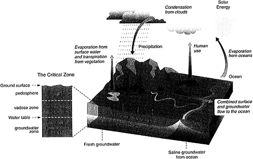
FIGURE 2.1 The Critical Zone includes the land surface and its canopy of vegetation, rivers, lakes, and shallow seas, and it extends through the pedosphere, unsaturated vadose zone, and saturated groundwater zone. Interactions at this interface between the solid Earth and its fluid envelopes determine the availability of nearly every life-sustaining resource.
The Critical Zone is a dynamic interface between the solid Earth and its fluid envelopes, governed by complex linkages and feedbacks among a vast range of physical, chemical, and biological processes. These processes can be organized into four main categories: (1) tectonics driven by energy in the mantle, which modifies the surface by magmatism, faulting, uplift, and subsidence; (2) weathering driven by the dynamics of the atmosphere and hydrosphere, which controls soil development, erosion, and the chemical mobilization of near-surface rocks; (3) fluid transport driven by pressure gradients, which shapes landscapes and redistributes materials; and (4) biological activity driven by the need for nutrients, which controls many aspects of the chemical cycling among soil, rock, air, and water.
Critical Zone processes are highly nonlinear and range across scales from atomic to global and from seconds to aeons ( Figure 2.2 ). The scientific challenges are illustrated by the problem of methane flux from wetlands and sediments, which reflects microbial processes and chemical gradients on small scales; the influence of vegetation and nutrient inputs on regional scales; and climatic factors such as precipitation and temperature on global scales. The scientific requirements thus include the development of process models that can capture the scale dependence (or invariance) and reconcile observations from one scale to another.
Practical applications often rely on the predictive capability of such models. To engineer the safe disposal of radioactive wastes, geoscientists must be able to predict reliably the effects of hydrologic and geologic processes on underground disposal sites for thousands of years. The historical record of direct observations is far too short to capture the full range of possible behaviors in the Critical Zone, and extensive use of the geological record becomes necessary. For instance, biogeochemical cycles are studied over decades to centuries through high-precision geochemical analysis of ice and sediment cores and marine organisms, while the geologic forcing factors (e.g., volcanism, topography) are constrained through the analysis of sedimentary and volcanic rocks deposited over millions of years.
Science Opportunities
Processes in the Critical Zone control soil development, water quality and flow, and chemical cycling, and they regulate the occurrence of energy and mineral resources. A better understanding of Critical Zone is necessary to assess the impact of human activities on the Earth surface and to adapt to their consequences. It is not possible in this short report to do justice to all of the pressing scientific issues that bear on the near-surface environment, hence only some pertinent examples are given.
|
Box 2.1. The Critical Zone The Critical Zone, depicted in Figure 2.1 , comprises the outermost layers of the continental crust that are strongly affected by processes in the atmosphere, hydrosphere, and biosphere. The upper boundary of the Critical Zone includes the land surface and its canopy of lakes, rivers, and vegetation, as well as its shorelines and shallow marine environments. On land, the shallower part is the vadose zone, in which unconsolidated Earth materials are intermixed with soil, air, and water. This porous medium is a host for many chemical transformations mediated by radiant energy, atmospheric deposition, and biological activity. Its storage capacity influences runoff and groundwater recharge, affecting both the flow and the quality of surface and subsurface waters. Within the vadose zone is the pedosphere, a collective term for soils at the land surface. The characteristic layering of the soil profile reflects the strong interaction of climate and biota in the upper portion and the accumulation of weathering, leaching, and decay products below. The water table marks the transition from the vadose zone to the deeper groundwater zone, where the pore space is filled by water. Like the vadose zone, the groundwater zone is a chemically reactive reservoir. The lower limit of the Critical Zone generally corresponds to the base of the groundwater zone, a diffuse boundary of variable depth extending a kilometer or more below the surface. The volume of water in the upper kilometer of the continental crust is an order of magnitude larger than the combined volume of water in all rivers and lakes. 1 The Critical Zone is perhaps the most heterogeneous and complex region of the Earth and the only region of the solid Earth readily accessible to direct observation. |
Global Climate Change and the Terrestrial Carbon Cycle
A significant amount of carbon is stored in soils and sedimentary rocks, thus the Critical Zone plays a key role in the global atmospheric CO2 balance. 1 Soil constitutes the third largest carbon reservoir, and work with carbon-14 tracers reveals that the distribution of soil organic matter strongly influences the means and rate of carbon uptake and release. The exchange of carbon among atmosphere, ocean, and terrestrial reservoirs is also affected by human land-use practices and land-use histories (e.g., agriculture,
|
1 |
A U.S. Carbon Cycle Science Plan. A Report of the Carbon and Climate Working Group, J.L. Sarmiento and S.C. Wofsy, co-chairs, U.S. Global Change Research Program, Washington, D.C., 78 pp., 1999 ( http://www.carboncyclescience.gov/planning.html#plan ). |
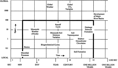
FIGURE 2.2 Spatial and temporal scales of Earth surficial processes, with those occurring in the Critical Zone enclosed in a solid frame. Modified from Opportunities in the Hydrological Sciences, National Academy Press, Washington, D.C., 348 pp., 1991. SOURCE: G. Sposito, University of California, Berkeley.
reforestation), as well as by silicate weathering. However, the temporal and spatial variability of carbon sources and sinks is not well documented, especially on longer time scales. New evidence regarding the influence of microscopic and macroscopic organisms on the weathering of silicate minerals and the transfer of soluble carbonates to the substratum may provide constraints on weathering reactions and global climate change.
The Interactions of Life, Water, and Minerals
Organic molecules and microorganisms strongly affect the kinetics of important geological and pedological processes. However, these materials studies are only beginning to address the quantitative significance of microbial interactions in mineral weathering, soil formation, and the geochemical cycling of metals, nutrients, and other elements or isotopes ( Figure 2.3 ). For example, it is clear that organic compounds influence the burial of reduced carbon and help drive the decay or retention of toxins in natural soils and sediments, although mechanisms for the preservation of carbon are still being debated. The interactions of water with minerals and other materials in soils, sediments, and rocks are critical in the dispersal and concentration of chemical species, the migration of contaminants, and the accumulation of natural resources. The architecture of porous media influences transmission dynamics, sorption-desorption kinetics, and chemical fates. Models of physical transport in heterogeneous media are being developed to understand chemical and biological reactions, nutrient cycling, and the fates of contaminants. Such models are being constrained by imaging and analytical measurements developed over the past few years and will provide new insight into the physical, biological, and chemical influences on water quality and availability.
The Land-Ocean Interface
New technology is yielding vastly improved insights to the nature and dynamics of coastal sedimentary environments. 2 For example, scanning airborne lasers are measuring seafloor bathymetry and topography of coastal areas with unprecedented accuracy and spatial coverage allowing assessment and understanding of coastal change in ways that were not possible only a
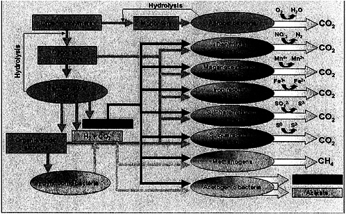
FIGURE 2.3 Metabolic pathways affecting the degradation of organic carbon. In nature, pathways for organic matter degradation are interlinked, with the final step depending on available oxidants. Oxygen is the most efficient reagent for respiration, but it can quickly be depleted in wet environments. In the absence of oxygen, bacteria will employ nitrate, metal oxides, sulfate, or sulfur to convert organic compounds into CO2. Additional pathways include the conversion of complex compounds into simple substrates, fermentation, and the cycling of carbon dioxide, hydrogen, methane, and acetate by Archea. SOURCE: K. Pedersen, Göteborg University, http://pc61.gmm.gu.se/gmm/groups/pedersen/basic_research_at_the_dbl.htm .
few years before. Using lasers and spectral imagers, it is now possible to map seafloor habitats and to determine whether the substrate is fixed or movable, living or fossil. These data also provide a better basis for integrated three-dimensional models of coastal ocean processes (e.g., tides, waves, currents). New models that integrate land-related processes (e.g., groundwater flow, sediment flux and storage, morphology of drainage systems and watersheds) are being used to understand nutrient loading in the coastal zone, as well as the ultimate fate of waste materials and pollutants in the ocean.
Tectonics, Climate, and Weathering
Topography, surface hydrology, sedimentation, and climate are intimately related. For example, erosion of the Tibetan-Himalayan plateau is related to precipitation and glacier development. Climate and hydrology interact to modify the surface expression of tectonic events, which in turn influence the rate and scale of fluvial responses. Topography exerts a major influence on erosion and the subsequent deposition of sedimentary rocks, as well as the formation and landscape diversity of soils. Similarly, removal of materials by surface processes influences tectonic uplift rates. Coupled geologic-hydrologic-climate studies promise a greater understanding of denudation rates, weathering processes, and the survivorship of mountain ranges.
Earth History
The history of the planet is recorded in soils, sediments, ice, water, and rocks. The geological record of environmental variations during the last several hundred thousand years provides the context for understanding the current climate system and its potential for future change. Important insights can also be gleaned from the behavior of the Critical Zone over even greater spans of geologic time: topographic relief, length of day, solar influx, and composition of the ocean and atmosphere have all varied significantly in the past. A good example, based on both careful geological field work and geochemical and isotopic observations, is the recent suggestion that the Earth went through a series of global glacial events (“snowball Earth”) about 750 million to 580 million years ago. The implications of such severe climatic conditions and other extreme events (e.g., extensive volcanism, meteorite impacts) for the evolution and maintenance of life on Earth are the subject of ongoing debate, stimulating new efforts to characterize extreme environmental conditions of the past.
New Tools and Observations
Many science disciplines—hydrology, geomorphology, biology, ecology, soil science, sedimentology, materials research, and geochemistry—are bringing new and powerful research tools to bear on the study of the Critical Zone as an integrated system of interacting components and processes. It is now possible to study the Critical Zone over a much greater range of length and time because of the wealth of data from satellites and aircraft that provide global information on scales from seconds to decades; advances in geochronology that extend the detailed record of near-surface environments to millions of years; imaging methods (e.g., electron and atomic force microscopes) and spectroscopic tools that probe soil materials to the atomic scale; and new information technologies, which permit the manipulation of large data sets and a variety of numerical simulations, from ab initio models of atomic and molecular interactions to global ocean and atmospheric circulation and mountain belt evolution. These technological advances have set up opportunities for novel cross-disciplinary activities.
-
Synchrotron-based X-ray spectroscopy can be applied in tandem with computational geochemistry to elucidate the molecular-scale mechanisms of key aqueous geochemical reactions related to mineral weathering, contaminant sorption and desorption, and nutrient cycling.
-
High-resolution electromagnetic and acoustic imaging of hydrological systems can be combined with molecular-scale mechanisms of aqueous geochemical reactions for accurate representations of transport in reactive systems. Such representations are essential for addressing silicate mineral weathering—a source of nutrients to the biosphere and a major control on the long-term CO2 budget—and contaminant transport.
-
The techniques of isotope geochemistry and molecular biology reveal the pathways involved in biogeochemical cycles and the formation of secondary minerals in weathering environments. 3 New geochemical and stratigraphic tools and techniques for dating individual minerals are furnishing insights into the behavior of the Earth’s surface with increasing temporal resolution.
-
Remote-sensing data, digital elevation models, and special dating techniques such as cosmogenic nuclide exposure ages can be used to validate a new generation of geomorphic transport models. 4 These models will allow a
-
more quantitative exploration of the dynamic interrelationships between tectonics, climate, soil diversity, and landscapes.
-
Microprobe, X-ray diffraction, scanning and transmission electron microscopy, X-ray tomography, and microchemical probes can be used to map the architecture of soils and to investigate material properties at the atomic-scale resolution needed for understanding sorption-desorption kinetics and other equilibrium processes. 5
-
Ground-penetrating radar and three-dimensional seismic imaging of sedimentary deposits permit modeling and prediction of physical properties of heterogeneous sediments in three dimensions. 6 Chemostratigraphic techniques can be used to correlate sediments among sedimentary basins, particularly between onshore and offshore basins.
-
In situ and aircraft sensors for measuring circulation patterns and mapping the bathymetry and substrate of the near-shore environment, combined with analysis of geochemical and sedimentological components and fluxes, can be used to quantify the variability of the geological, biological, and atmospheric components of coastal ecosystems.
Need for Coordinated Field Work and Integrated Modeling
The integration of disciplinary research is the key to future progress in the science of the Critical Zone. This theme permeates the discussion of many other aspects of Earth science in this report, but, in the case of the Critical Zone, it presents some special challenges, in part because of the sheer number of the disciplines and the diversity of their approaches, but more profoundly because of the spatial scales intrinsic to the scientific issues. Although Critical Zone processes often involve the global aspects of atmospheric and oceanic transport, many of the most intense interactions occur in relatively localized regions of the solid Earth—for example, over dimensions less than the characteristic horizontal variations in topography and near-surface geology (tens to hundreds of kilometers) or the thickness of the zone itself (about a kilometer). Indeed, much of the science to be done will require the in situ study of microscopic processes that are subject to numerous contingencies— physical, chemical, and biological—which vary from one surface environment to the next. Not surprisingly, disciplinary integration has proceeded more
rapidly in the study of global-scale geosystems, which manifest a more obvious set of unifying concepts, diagnostic behaviors, and simple symmetries—for example, the dipolar magnetic field (core dynamo), the shifting mosaic of plate tectonics (mantle convection), or the largely zonal structure of global circulation (climate system).
New mechanisms are thus needed to encourage multidisciplinary collaborations on Critical Zone problems, especially on local and regional scales. Modeling activities that employ conceptual and numerical tools to integrate different types of data are clearly important. However, the primary deficiency at this stage of the science is the difficulty in mounting field work to collect measurements that are sufficiently localized and simultaneous as well as dense and comprehensive enough to constrain process-based models of Critical Zone behaviors. Real progress will require some way to coordinate the field investigations of hydrologists, pedologists, geochemists, geobiologists, mineralogists, and other geoscientists in localized regions, often for extended periods of observation, and to encourage the integration of these data with controlled laboratory measurements and system-level models.
One mechanism for encouraging this type of problem-focused, multidisciplinary field work is through the establishment of “natural laboratories” in which detailed, long-term observations can be made using a variety of disciplinary tools. As discussed in Chapter 3 , such a program would also provide new opportunities for scientific advancement in many other areas of Earth science.
GEOBIOLOGY
Life is inextricably linked to the Earth, so it is not surprising that some of the most challenging problems of geology and biology are intimately interwoven. The synthesis of these two sciences is geobiology, which addresses the interactions of biologic and geological processes, the evolution of life on Earth, and the factors that have shaped the current and past biospheres. Important issues include the following:
-
origin of prebiotic molecules and life, and its early evolution;
-
emergence and divergence of metabolisms and morphologies;
-
effects of organisms on the physical and chemical characteristics of Earth and its fluid envelopes;
-
nature of ecosystems and their response to environmental perturbations of many types; and
-
the rules that govern biodiversity dynamics, including selectivity in
-
extinction and recovery, interactions among groups, and the effects of geographic scale. 7
Much can be learned from studies of present-day systems, but access to the geological record also permits these issues to be explored over longer time scales and over a wider range of Earth system states. Major scientific breakthroughs are inevitable because of the enormous growth in the power of new techniques and of conceptual advances in the contributing biological, geological, and geochemical disciplines. Geobiological research results bear directly on a wide array of important scientific and societal issues, including the nature of the Critical Zone, the stability and resilience of ecosystems under stress, and the origin and evolution of life itself.
Geobiological processes operate over a wide spectrum of temporal and spatial scales—from small-scale, rapid exhalation of O2 by cyanobacteria, to cycling of carbon through communities of marine phytoplankton and rain forests, to restructuring of regional and global ecosystems in the wake of major extinction events, to shifts in reef composition in response to slowly changing rates of seafloor spreading ( Figure 2.4 ). Understanding the complex interactions that occur across such a broad space-time spectrum is challenging and requires an integrated approach that treats ecosystems as components of larger geosystems.
Recent Advances
Over the past decade, Earth scientists have gained much better appreciation of the impact of living organisms on their surroundings, which is forcing a critical reexamination of the relative importance of the various factors that control Earth processes.
Climate Studies
Biominerals provide a sink for atmospheric CO2, and their formation is directly linked to the supply of calcium and magnesium from chemical weathering of silicate and carbonate minerals. Organic by-products may, in turn, increase dissolution rates of silicate minerals by factors ranging from 2 to more than 100. Such biological-climate feedback mechanisms (including
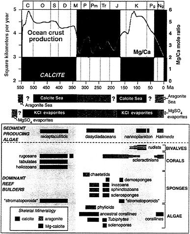
FIGURE 2.4 Temporal correlation between seafloor spreading rate (top) and skeletal mineralogies of sediment-producing algae and dominant reef builders through the Phanerozoic (bottom). The seafloor spreading rate and mineralogies of dominant hypercalcifying marine taxa are thought to be linked through the oceanic magnesium to calcium ratio, here inferred from the ocean crust production rate. The magnesium-calcium ratio is also thought to have played a role in observed patterns of evaporite deposit mineralogies (middle). Magnesium-calcium ratios less than 2 yield “calcitic” seas whereas ratios greater than 2 yield “aragonitic” seas. SOURCE: Modified from S.M. Stanley and L.A. Hardie, Hypercalcification: Paleontology links plate tectonics and geochemistry to sedimentology, GSA Today, v. 9(2), p. 1-7, 1999. Modified with permission of the publisher, the Geological Society of America, Boulder, Colorado USA. Copyright ©1999 Geological Society of America.
the albedo of land vegetation, burial of organic carbon, production of biogenic compounds such as dimethyl sulfide that affect cloud formation, and linkages between oceanic biological productivity and iron and phosphorus supply) are becoming important parameters in global change models. Pollen data from cores, corroborated by isotopic and chemical evidence from reef corals, equatorial glaciers, and groundwater, provided the first evidence of tropical cooling during the Last Glacial Maximum, causing reconsideration of heat transport in global circulation models (GCMs). Paleobotanical evidence from the western United States in the late Paleocene has significantly refined the treatment of orographic effects in GCMs during rapid warming events, and evidence of extensive warm climate vertebrates and plants near the Cretaceous poles provides important constraints for modeling times of extreme warmth.
Biological Controls on Earth Chemistry
The pathways and extent to which organisms fundamentally control the distribution of elements (and isotopes) in the Earth’s crust are now beginning to be understood. Most of the iron, sulfur, phosphorus, carbon, and nitrogen in soils and sediments pass through biological repositories, and there is growing evidence that metabolic processes have detectable effects on other major (e.g., Ca, Si) and minor (e.g., As, Mo, U) elements in seawater. Results of such studies provide the mechanistic basis for modeling biogeochemical cycles and for environmental studies of the mobility and fate of toxic compounds. New insights into the roles of microbial metabolism, organic chelators, and sediment-irrigating and -advecting plants and animals in processes such as mineral dissolution, mineral precipitation, soil formation, and sedimentary diagenesis are opening the way for more detailed understanding of Critical Zone processes both modern and ancient.
Molecular Geobiology
New data from molecular biology, developmental biology, and paleontology have invigorated studies of the origins, evolution, and ecology of major biological groups. Important advances include the construction of evolutionary trees of all living things, based primarily on genetic similarities of living taxa, and the placement of the major branching events of these trees into their correct geological context ( Figure 2.5 ). Improvements in instrumentation and preparative techniques have made it possible to identify and characterize the isotopic composition of biomarker molecules in sedimentary rocks, providing evidence for the operation of metabolic pathways important in biogeochemical
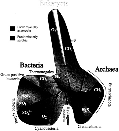
FIGURE 2.5 Evolutionary tree showing the relationship between the major branches of life. Some key metabolic by-products (e.g., CO2) of the major groups of organisms are labeled in white. Orange and green colors represent aerobic versus anaerobic environments. Contours, representing time in billions of years, are schematic and are anchored only by a few minimum dates (black boxes) gleaned from the geologic record. Correlating genomic events with the geological record remains a significant challenge. Where the geologic record indicates considerable diversity within a group, the line depicting the lineage has been widened (yellow and blue wedges). SOURCE: Reprinted with permission from J.F. Banfield and C.R. Marshall, Genomics and the geosciences, Science, v. 287, p. 605-614, 2000. Copyright 2000 American Association for the Advancement of Science.
cycles through time. Key discoveries include molecular confirmation that cyanobacteria were already producing major amounts of oxygen 2.5 billion years ago and that organisms with structurally complex eukaryotic cells were
possibly present at least 2.7 billion years ago, 500 million to 600 million years earlier than the oldest known eukaryotic fossils.
The discovery that most living animals share the same core set of developmental genes has begun to make it possible to understand the genetic basis for the differences between animals. Integration of these genetic data with new morphological and geochronologic data from the fossil record allows unraveling of the evolutionary events that led to novel morphologies, from the earliest multicellular animals to the origin of flowers and the vertebrate skull. This offers the opportunity for understanding key events, such as the Cambrian explosion of multicellular animals ( Figure 2.6 ) and the mid-Paleozoic invasion of land. Geological and molecular data can also be used to calibrate molecular clocks based on differences between the DNA of living species; these clocks can then be applied to lineages otherwise lacking a rich fossil record.
Discoveries of entirely new microbial organisms in ecologically and geologically extreme environments (extremophiles) have greatly broadened the concept of the versatility of life; microorganisms have been found kilometers deep in Antarctic ice, in active vents along midocean ridges, and in fluids with a pH of zero. Subduction zones likely contain the Earth’s deepest biota, sustained by energy from chemical redox reactions rather than solar radiation.
Studies of organic reactions on mineral surfaces have led to a new understanding of how key prebiotic compounds were formed early in Earth history. Molecules such as thioesters and acetic acid have been created under geochemical conditions relevant to the early Earth, and nucleotides and amino acids have been polymerized, providing possible clues to the origin of life.
Evolutionary Innovations
One of the most striking paleontological observations has been the uneven distribution of evolutionary innovations in time and space. Pulses of innovation following extinction events, such as the early Cenozoic radiation of mammals following the extinction of dinosaurs and other Mesozoic dominants, are now recognized as a crucial component of the evolutionary dynamic and are the focus of a major new research direction linking paleobiologists, evolutionary biologists, and ecologists. Evolutionary innovation also has a strong spatial component, with major novelties appearing in disturbed environments, both on land and in the sea, and in tropical latitudes. Recoveries from extinction events and diversifications show significantly different trajectories in different regions that sum to lasting effects on the global biota ( Figure 2.7 ).
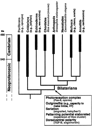
FIGURE 2.6 Phylogeny of selected animal phyla, showing the stratigraphic extent of their fossil records (body fossils only). Inferred character states of the last common ancestor of the bilaterian animals are listed in the box. The distribution of key developmental genes, along with comparative anatomical data, can be used to infer the developmental potential and soft tissues present in ancestors of these phyla, even though no fossils of these ancestors exist. Most of the developmental data come from a few living “model” systems (species names in red). Some of the genes identified from these and other species that play a role in developmental capacity or tissue (indicated in the box) are also shown in red. There is great uncertainty in the time of divergence of the animal phyla: the fossil record is consistent with divergence shortly before the beginning of the Cambrian, whereas molecular clocks suggest divergence perhaps as much as 1000 million years ago. SOURCE: Modified with permission from A.H. Knoll and S.B. Carroll, Early animal evolution: Emerging views from comparative biology and geology, Science, v. 284, p. 2129-2137, 1999. Copyright 1999 American Association for the Advancement of Science.
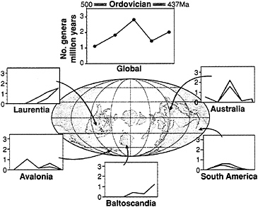
FIGURE 2.7 Patterns of diversification of Ordovician bivalve molluscs around the world. As with other marine organisms, the pattern varies by geographic location, indicating that the Ordovician radiation (the largest diversification of animal genera seen in the fossil record) was not a globally synchronous event. Analysis of the geological histories of these regions suggests that local tectonics played a role in the creation of niches required for diversification to occur. SOURCE: Reprinted with permission from D.H. Erwin, Evolution —after the end—recovery from extinction, Science, v. 279, p. 1324-1325, 1998. Based on data from A.I. Miller, Comparative diversification dynamics among paleocontinents during the Ordovician radiation, Geobios, MS 20, p. 397-406, 1997, and A.I. Miller, personal communication, and map from C.R. Scotese and W.S. McKerrow, in Palaeozoic Paleogeography and Biogeography, W.S. McKerrow and C.R. Scotese, eds. (Geological Society of London Memior 12, p. 1-21, 1990). Copyright 1997 American Association for the Advancement of Science.
Environmental and Ecological Dynamics
Paleobiological analysis of the geologic record has provided insights into the dynamics of ecological communities that could never be discovered through annual or decadal observations of modern systems or by theory alone. For example, data on North American land plants, insects, vertebrates, and marine invertebrates show that many species shifted their geographic ranges independently, rather than moving as cohesive communities, in response to climate changes since the Last Glacial Maximum. This observation has important implications for the response of natural and agricultural
systems to anthropogenic climate change. Comparative analyses of other events in the geological record are revealing the complexity of biotic response. For example, the Late Paleocene Thermal Maximum, possibly enhanced by a massive release of methane hydrates at ocean margins, produced a surprisingly mild extinction, and in some environments even promoted diversification, outside of the deep sea.
New Tools and Capabilities
New and improved biological, chemical, geological, and paleontological methods hold enormous potential for geobiological research. These capabilities allow investigations that would have been virtually inconceivable in past decades.
-
Technical advances in molecular approaches such as genomics (the mapping and sequencing of genomes and analysis of gene and genome function), proteinomics (characterizing the structure-function relationship of proteins), and developmental biology provide a means of (1) assessing the diversity of organisms and of biological metabolisms in modern and ancient environments; (2) tracing the role of gene transfer between species, which is relevant to the evolution of life; (3) estimating phylogenetic relationships within and among major microbial, plant and animal groups; and (4) unraveling the mechanistic basis of morphological innovation.
-
Combinations of powerful solid, surface, solution, and organic analytical techniques with conventional and molecular biological approaches can now be used to (1) tackle the dynamics of trace and toxic element cycling between solutions, solids, and biosphere reservoirs; (2) unravel the mechanisms of biomineralization and the pathways of microbial degradation of organics; (3) study the ecology of macroorganisms (through analyses of bones, teeth, and shells); and (4) develop kinetic models for biogeochemical processes.
-
New molecular and isotopic techniques, applied to the remains of organisms and in analysis of fossil morphologies, are being developed for tracking levels of atmospheric CO2 and O2 and differentiating oceanic water masses and their movements over geologic time. The combination of these methods with expanded computer models and a better understanding of ocean and atmospheric circulation will greatly advance knowledge of the factors that affect climate and the geochemical and biological cycling of key elements and molecules in the environment.
-
Recent technical improvements have made it possible to measure radioactive and stable isotopic differences with much higher precision and
-
on much smaller samples than was previously possible. New methods of age interpolation (e.g., based on periodic orbital forcing functions), data integration, and quantification of gap effects and diachrony in geochronological datums are leading to significant refinements of the geological time scale. The increased temporal acuity offers the opportunity to test the plausibility of mechanisms proposed for major events seen in the rock and fossil records, such as the end-Permian mass extinction.
-
Comprehensive studies of past and present environments, combined with numerical simulations and “meta-analyses” of diverse data sets, are dramatically improving our insight into the quality of the geological record. New methods for estimating the completeness of sedimentary successions and evaluating hiatuses ( Figure 2.8 ) are leading to improvements in the sampling and analysis of the rock and fossil records, and field and laboratory studies are leading to a greater understanding of the processes of selective modification and preservation of the geologic record.
In addition to new tools, advances in geobiology depend on new field studies of regions and key stratigraphic intervals, phylogenetic and systematic analyses of key groups, and reevaluation and organization of existing data archived in museums, written records, and electronic media. These investigations yield vital new information on the geography, environmental and evolutionary context, age, and composition of biotas and on the deployment of evolutionary lineages in time and space.
Science Goals and Challenges
Recent advances in relevant technologies and capabilities have set the stage for significant progress in understanding the role of biological processes in geosystems, the evolution of life on Earth, and the factors that have shaped the current and past biospheres. Fundamental new knowledge at the interface of the biological and Earth sciences is anticipated in the following broad areas:
-
the interrelationship among organisms, biological processes, and the fundamental physical and chemical properties of the Critical Zone;
-
the extent to which geological processes, such as weathering and mineral precipitation, are mediated by biological processes, and the mechanisms by which this mediation occurs;
-
the ways in which biogeochemical cycles operate and are controlled or modulated by physical, chemical, and biological processes;
-
the role of physical factors, including rare events, in structuring and changing the composition and organization of biological communities;
-
the relative importance of intrinsic and extrinsic factors in controlling the nature and rates of biological innovation;
-
the rates and selectivities in biological extinction and recovery, and how these scale to duration, magnitude, and geographic extent of changes in the physical and biological environment; and
-
the causes of environmental change, including the ways in which biological processes contribute to and can be used to remediate environmental damage.
EARTH AND PLANETARY MATERIALS
Research on Earth and planetary materials has undergone significant growth over the past two decades, building on major advances in the well-established domains of geochemistry, mineralogy, petrology, and soil science, as well as in the newer fields of geomicrobiology and biomineralogy, mineral and rock physics, and nanophase and planetary materials studies. This research is also being stimulated by new collaborations of geoscientists with chemists, physicists, molecular biologists, and materials scientists. Together, these disciplines have laid the groundwork for the ambitious objective of attempting to understand, from the atomic level up, the most significant processes that determine the current state and geological evolution of planets in general and Earth in particular.
Recent Advances
Earth and planetary materials research is based on an atomistic approach—establishing properties at the molecular level in order to understand materials and processes at much larger scales. It has involved the development of major new research tools. For example, mineral physicists have been at the forefront of developing synchrotron beamlines for microdiffraction and spectroscopy, experimental tools for studying materials at ultrahigh pressures and temperatures, resonance techniques for superprecise measurements of elastic properties, and quantum mechanical methods for modeling complex minerals. Characterizing Earth materials with such methods is essential for quantifying the underlying processes and driving forces at play.
These capabilities also make it possible, for the first time, to study naturally occurring nanophases and mineral surfaces in great detail, for instance, tracking low concentrations of elements in soils and related biological materials. Understanding how both naturally occurring and human-introduced
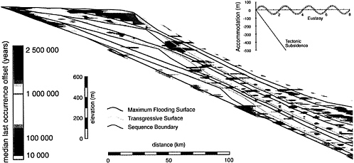
FIGURE 2.8 . Two-dimensional synthetic section across a sedimentary basin from onshore (left) to offshore (right). The model used to produce the synthetic section includes four eustatic sea-level cycles, producing four depositional sequences, superimposed on a constant rate of tectonic subsidence (upper right). Maximum flooding surfaces, transgressive surfaces, and sequence boundaries represent time lines through the section. While the sequences were being deposited, species with different ecological (depth) preferences were allowed to evolve and to become preserved in the forming rock record. The colors represent differences in each species’ true time of extinction and the time of extinction observed in the synthetic section: high fidelity of the fossil record is shown in blue, and low fidelity is shown in red. The fossil record is poor onshore and offshore above the transgressive surfaces. Such models are useful for understanding large-scale biases in the sedimentary rock and fossil records. SOURCE: Reprinted with permission from S.M. Holland and M.E. Patzkowsky, Models for simulating the fossil record, Geology, v. 27, p. 491-494, 1999. Copyright 1999 Geological Society of American.
elements are released by soil, biologically cycled, and moved through the food chain is important to ensuring food security and safety while maintaining or improving environmental quality.
It is now possible to reproduce experimentally the high pressures and temperatures existing throughout the Earth and to perform accurate measurements of material properties at these conditions. This is significant because seismology is revealing the structure of the Earth’s deep interior with rapidly improving resolution. By comparing seismological observations with laboratory measurements and theoretical analyses ( Figure 2.9 ), it is possible to determine the state and composition of the planetary interior as well as the processes by which it evolves.
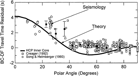
FIGURE 2.9 Quantum mechanics at the Earth’s center. Theoretical calculations (curve) of the elastic properties of hexagonal close-packed (HCP) iron at conditions of the inner core reproduce seismologically observed variations of travel times at depth (points). The observations represent the time required for seismic waves to travel through the inner core, showing that travel times (hence wave velocities) vary systematically with propagation direction, from polar (along the Earth’s rotation axis: polar angle = 0°) to equatorial (polar angle = 90°). The theory is from “first principles,” meaning that the quantum mechanical calculations are free of any experimental input. SOURCE: Modified from Microscopic to Macroscopic: Opportunities in Mineral and Rock Physics and Chemistry, results of a workshop held in Scottsdale, Arizona, May 28-30, 1999. Reprinted with permission from L. Stixrude and R. E. Cohen, High-pressure elasticity of iron and anisotropy of earth’s inner core, Science, v. 267, p. 1972-1975, 1995. Copyright 1995 American Association for the Advancement of Science.
Recent scientific developments are illustrated in the following examples: 8
-
Experimental discovery and initial characterization of the high-pressure metallic state of hydrogen, considered to be the predominant material making up the interiors of giant planets and stars—its existence was theoretically predicted 60 years earlier, but the new measurements reveal unexpected properties for metallic hydrogen and are leading to significantly improved models of the structure, dynamics, and evolution of giant planetary interiors. Understanding giant planets is required to decipher the origin of planetary systems (including our own) and is further motivated by the recent discovery of giant planets outside the solar system.
-
The friction laws for rock, including its dependence on sliding velocities, have been determined experimentally for the first time, providing new insights into the physics of earthquake rupturing and unifying many observations of seismic phenomena that are relevant to assessing earthquake hazards. Moreover, rock has been found to exhibit highly nonlinear properties (e.g., in elastic wave propagation) among other reasons, because of the chemical and physical interactions of fluids with the formation and propagation of fractures at microscopic to tectonic scales. Nonlinearity means that small forces can have large effects.
-
Newly discovered mineral phases that are formed at high pressures lock water, carbon dioxide, and other “volatile” molecules into their crystal structures. The Earth’s interior is thus likely to contain far more water and other volatile species than the hydrosphere, fundamentally altering current views of how the oceans and atmosphere have evolved over geologic time.
-
Novel techniques are revealing for the first time the physical structures and chemical properties of mineral surfaces ( Figure 2.10 ). Experimental measurements and theoretical analyses are providing a molecular-scale understanding of the detailed interactions between fluid (within pores or along grain boundaries) and mineral phases, with far-reaching implications for disciplines ranging from volcanology to seismology and for applications ranging from resource extraction to environmental remediation. In particular, the details of fluid-mineral interactions determine the degree, rate, and paths with which surface and underground contaminants migrate and the means by which such effects can be mitigated.
-
Land resources are composed of soils with active colloidal fractions dominated by organic-mineral nanophases whose surfaces control the chemical speciation and fate, mobility, bioavailability, reactivity, transport,
-
and toxicity of these constituents. Such knowledge has important societal and environmental implications in the Critical Zone, for example, in the sustainability of agriculture and water resources.
Science Opportunities
The momentum associated with recent discoveries, improved facilities, and new collaborations between disciplines offers a glimpse into future possibilities. The coming decade will see the emergence of major opportunities for research on Earth and planetary materials.
Development of Intense Neutron Beams and Other Powerful New Probes of Material Properties
Neutrons are uniquely suited for documenting the molecular sites of hydrogen (including water and hydroxide) in minerals and fluids; the textures of rocks, soils, and other polycrystalline materials; the atomic configurations in fluids; and the thermodynamic properties of crystals. Dedicated synchrotron X-ray beamlines, fully instrumented for sophisticated in situ experiments, will lead to an entirely new class of experiments with hundredfold or greater increases in spatial, temporal, and spectral resolution. These technical developments will, with little doubt, lead to breakthroughs in applied as well as basic research, from monitoring fluid-mineral interactions to clarifying the evolution of planetary interiors.
Retrieval of Samples From Other Planets, Interplanetary Space, and Comets
Future space missions, already initiated or planned, are expected to provide samples of cometary, asteroidal, and solar materials that are representative of the substances from which the planets formed. Specimens may also be returned from Mars within 10-20 years. These samples will be small and are expected to contain a significant fraction of dust-size particles, putting a premium on the use of modern high-resolution analytical techniques. Mineral surfaces and interfaces will require special study, especially to document potential precursors of biological molecules and organic processes in extraterrestrial materials, which will be a high priority for identifying any traces of life.
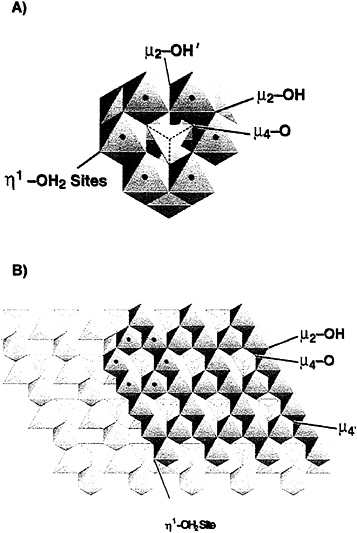
FIGURE 2.10 Dissolution of minerals. Experiments reveal the detailed processes controlling mineral-water interfaces, with the molecular arrangement of aluminum within the water (• in A) being found to closely match that at the surface of a γ-alumina crystal (• in B). Shaded octahedra and tetrahedra represent AlO6 and AlO4 molecular units, respectively. SOURCE: B.L. Phillips, W.H. Casey, and M. Karlsson, Bonding and reactivity at oxide mineral surfaces from model aqueous complexes, Nature, v. 404, p. 379-382, 2000. Reprinted by permission from Nature copyright 2000 Macmillan Magazines Ltd.
Application of Molecular Biology to Earth Materials
Microorganisms and nanocrystalline phases are now recognized as playing a key role in weathering and other fluid-soil-rock interactions within the Critical Zone. Geomicrobiology is just now gaining momentum and has already uncovered major surprises about how organisms influence mineralogical and geochemical processes in the natural environment. Molecular biological technologies offer powerful means for identifying both the species and the functionality of organisms in a wide variety of environments (see “Geobiology” above). Only a small fraction of the Earth’s surface has been examined so far, suggesting that many significant discoveries remain to be made, including extreme habitats at depth in the crust.
Long-Term Observations in Natural Laboratories
Field observations are required to study material properties and processes on length and time scales inaccessible in the laboratory, as well as to assess which processes, among the many possibilities, are most significant in controlling material properties under natural conditions. In situ measurements of geological materials will be an important complement to laboratory experimentation for monitoring and remediating the environment, characterizing geological resources, and assessing geological hazards. Natural laboratories have enormous potential as facilities where data sets with appropriate detail and precision can be collected systematically over the long term under natural conditions. For example, the San Andreas Fault Observatory at Depth (SAFOD), proposed as part of the EarthScope initiative ( Box 2.2 ), will use deep drilling to recover samples and collect in situ data on the fault zone properties that will permit a better interpretation of laboratory experiments on rock friction and failure.
These opportunities in Earth and planetary materials research involve technical advances, research efforts, or space missions that have already been initiated. There are probably many other unforeseen developments that will take place over the coming decade. It is new linkages between geoscientists and researchers in other disciplines, such as chemistry, physics, and molecular biology, that have led to many of the recent breakthroughs as well as several of these opportunities.
The overall objective of research on Earth and planetary materials is to obtain a full understanding of geological processes starting at the atomic scale. Modern instrumentation, along with quantum and statistical mechanical computations, are providing powerful new capabilities for achieving this objective. Although many materials remain to be characterized, the accom-
plishment of the past decades has been to identify many of the key materials and properties controlling the Earth’s geological processes. A major intellectual challenge that remains is to understand how material properties and processes can be scaled from laboratory to planetary scales of distance and time.
THE CONTINENTS
Almost the entire span of Earth history is recorded in the continental crust. Rocks on the surface of the continents provide an archive reaching back at least 4 billion years, 20 times beyond the oldest oceanic crust and almost nine-tenths the age of the solar system. Thus the continents provide the only accessible long-term record of the Earth.
The continents have grown by magmatism, deposition of sediments, and crustal accretion and have been reshaped through tectonism, metamorphism, and fluid flux from the deep Earth. Properly interpreted, continental geology yields information about these processes and about the large-scale dynamics that control mantle convection, planetary differentiation, plate motions, and climate throughout Earth history. Today, many fundamental and controversial ideas about the continents await testing through the integration of field geology and geomorphology with new technologies in geochemistry, geophysics, and geodesy.
In recognition of the need for broadly based, multidisciplinary studies of the continents, EAR established the Continental Dynamics (CD) Program in 1982 with the objective of augmenting its highly successful core programs in tectonics, geophysics, and geochemistry ( Appendix A ). The CD program has flourished, sponsoring many regional investigations of the continental crust and upper mantle around the globe, encouraging the development of new tools and setting the stage for a new phase of investigation.
Recent Advances
Many of the most significant advances of the past decade have involved integration of new remote-sensing data and computational technologies with field and laboratory observations.
-
The advent of geodetic techniques based on the Global Positioning System (GPS) and interferometric synthetic aperture radar (InSAR) satellites has made it possible to observe the motions of crustal fragments on time scales from seconds to decades and to record relative positions accurate to a
-
few millimeters over baselines of thousands of kilometers. Through the combination of space geodesy and ground-based geological mapping, modern plate boundaries can now be dissected with an unprecedented level of precision ( Figure 2.11 ), paving the way for advances in earthquake physics and crustal rheology.
-
Construction of precise topographic data sets and digital elevation models has reinvigorated the study of active tectonics and surface processes though the analysis of landforms and river drainages. The quantification of topographic relief has been joined with process-oriented field work and simulations based in dynamical systems theory to explore the strong interactions between tectonism, erosion, and climate.
-
Isotope geochronologists have dated rocks as old as 4 billion years with an uncertainty of less than 1%, making it possible to measure the rates at which major, sometimes catastrophic, events occurred in the distant past. These constraints have provided a much more precise temporal framework for investigating the field relationships among geologic, climatic, and biologic phenomena (e.g., volcanic eruptions, mass extinctions, and major glacial events).
-
Seismic tomography has provided three-dimensional images of the continents that show the strong correlation between surface geology and mantle structure. The ancient cratons are underlain by deep “keels” extending to depths of several hundred kilometers, raising important questions about the composition and evolution of the subcontinental mantle that can be addressed by geochemical observations. Measuring the directional dependence of seismic wave propagation (seismic anisotropy) and comparing this with laboratory measurements of mineral deformation and rock textures have made it possible to infer strains within the mantle part of the lithosphere that can be related to crustal deformations mapped at the surface.
-
Advances in petrology and geochemistry have elucidated the pressure and temperature variations with time in rocks metamorphosed over a wide range of depths, including at subcrustal conditions. These techniques have been applied to samples brought up from depths of hundreds of kilometers in continental volcanic eruptions, allowing geochemists to constrain the history of even the deepest parts of the continental lithosphere. Based on comparisons with the results of high-pressure mineral physics experiments, some of these rocks appear to have come from as deep as the lower mantle, providing unique data on large-scale dynamical processes of the Earth’s interior.
Basic research on continental processes has been applied to many of the practical problems discussed in Chapter 1 , ranging from the search for natural resources to the mitigation of natural hazards. For example, field work on ancient fault ruptures (paleoseismology) has been linked with laboratory
studies of rock friction and theoretical models of stress transfer to clarify how stress interactions among active faults affect the sequencing of large earthquakes ( Figure 2.12 ). Excellent progress has also been made in understanding the shorter-term, smaller-scale processes that control earthquake nucleation and rupture dynamics. Combining this information with simulations of seismic wave propagation through complex geological structures is leading to significant improvements in the ability to forecast damaging ground motions— information crucial to seismic hazard analysis and earthquake engineering.
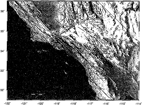
FIGURE 2.11 Geodetically determined (GPS) velocities, relative to stable interior North America, for southern California and adjacent regions of Nevada, Arizona, and Mexico. Stations located on islands in the Pacific Ocean move approximately with the Pacific plate, at ~50 mm per year northwest. In the northern portion of the diagram the zone of active strain between the Pacific plate and North America is several hundred kilometers in width, while in the southern portion of the diagram, most of the strain is localized within a zone 50 km wide and occurs on or near the San Andreas Fault. Comparison of actively accumulating deformation obtained from geodetic measurements yields important insights into seismic risk.
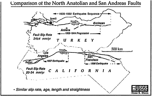
FIGURE 2.12 . Comparison between major, plate-bounding active strike-slip faults in California (San Andreas Fault) and Turkey (North Anatolian Fault) showing similarities in length, slip rate, and general geometry of the fault zones. Both faults have a history of frequent earthquakes of magnitude 7 and higher, with irregular time intervals of decades to centuries between major events. The westward progression of earthquake epicenters in northern Turkey, beginning in 1939 and culminating in the Izmet earthquake of 1999, is cause for concern because the city of Istanbul (population 15 million) lies only 100 km to the west of the Izmet epicenter. Major devastation and loss of life are to be expected if earthquake activity migrates westward into this urban area. It is not known if similar patterns in earthquake migration might occur along the San Andreas Fault, but this question could be addressed through paleoseismological studies of San Andreas earthquakes over the last 10,000 years. SOURCE: R. Stein, U.S. Geological Survey.
Science Opportunities
The next decade will see discoveries derived from the rapidly expanding capabilities to observe both ancient and modern continental processes at a new level of detail. Particularly promising are the recent advances in dating capabilities and the ability to image structures deep within the Earth, allowing the temporal record obtained from geologic and geochemical studies to be correlated with ever more accurate knowledge of the Earth’s three-dimensional structure.
Surface Processes, Climate, and Tectonics
What were once thought to be one-way forcing functions are now recognized to act in both directions, with feedback coupling continental tectonics, erosion processes, climate, and the composition of the atmosphere and oceans. The onset of the Indian monsoon and the desertification of sub-Saharan Africa can be related to the uplift of Tibet; the melting of midcrustal rocks and topographic collapse of mountain belts can be related to rapid denudation rates at the surface; and carbon sequestration in the oceans and atmospheres can be related to the formation and destruction of passive continental margins that are sites of carbonate deposition. These strong interdependencies are only beginning to be investigated, and the long-term evolutionary effects are very poorly known. Recent calculations suggest that current plate tectonics may be subducting up to an order of magnitude more water into the mantle than is being released out of the mantle by surface volcanism; taken at face value, the model implies that the oceans are draining back into the planet at the present time. This controversial example illustrates the unprecedented opportunities for basic research on the coupling of Earth processes from the mantle through the crust and into the oceans and atmosphere.
Active Deformation
The global forces that drive surficial motions are rooted in the mantle, but the processes of crustal deformation are governed by the ductility, fracture, and friction of rocks. These properties are not simple functions of thermodynamic state; rather, their variation is coupled in a complex way to the evolution of stress and strain. A more complete picture of the stress distribution and deformation mechanisms will require the combination of neotectonic studies with laboratory-based rock mechanics, earthquake seismology, and tectonic
geodesy. 9 Particular opportunities exist for high-resolution geodetic measurements near active faults and other regions of concentrated deformation, for more detailed paleoseismic studies to gain a better history of particular fault ruptures, and for more extensive geological investigations of the way that older fault systems evolved through time. Direct measurement of fluid pressures and in situ sampling by deep drilling will be needed to understand the role of water, which is a key constituent in deformation processes.
Fluids in the Crust
Fluids play a major role in crustal processes at all depths, even in small abundances. Laboratory experiments have shown that trace amounts of water can have substantial effects on the ductile and frictional properties of rocks, underlining the importance of this ubiquitous fluid in deformation processes. The effects of fluid mobilization on chemical and thermal processes are also well established by direct observations in shallow environments, and they can be reliably inferred from high-resolution geophysical measurements and observations on metamorphic rocks uplifted from depth. The microscopic fluid-mineral interface, often modulated by biological processes (at least in the near-surface environment), governs the way in which fluids permeate and react with soils and other crustal materials. Many problems related to water and other fluids in the near-surface Critical Zone have been discussed in earlier sections of this report. Little is currently known about the dynamics of fluid conditions in the deeper parts of the crust. For example, the interior zones of well-developed strike-slip faults such as the San Andreas are thought to be much weaker than typical crustal rocks, and increased fluid pressures in the fault zone, perhaps dynamically maintained by the earthquake cycle itself, have been implicated as a possible cause of this weakness. Surface observations have been inadequate to test this hypothesis, and deep drilling will probably be required to resolve the issue. Other problems include the influence of water on the mechanics of detachment surfaces and décollements, the nature of deep circulation systems in hydrothermal areas and sedimentary basins, the fluid content of the lower crust, and the fluid flux from the mantle.
Lower Continental Crust
The lower continental crust forms a weak, ductile layer that reduces the coupling between the brittle deformation of the earthquake-producing upper crust and the aseismic motions in the mantle. Its properties, which are highly variable from place to place, play an important role in determining the width of active fault zones, postseismic response and interseismic strains, the heights of mountain belts, and the subsidence rates of sedimentary basins and passive continental margins. Surprisingly, however, some of the most basic parameters of the lower crust, such as its average composition, are still poorly constrained, and the role of key processes, such as magmatic underplating, remains largely speculative. Better knowledge of the lower crust can be obtained from geochemical and rock mechanical studies of tectonically exhumed sections, as well as from samples brought to the surface in volcanic eruptions and from geophysical research on active and ancient deformations. Substantial geological field studies in key areas will be needed to set up the tectonic framework for such investigations, and the integration of disciplinary data will require the construction of quantitative models that can account for the geomechanical behavior of the continents from the surface to the mantle.
Continental Deep Structure
Substantial knowledge has been gained about the structure of the continental lithosphere, but fundamental questions concerning its composition and formation remain unanswered. They pertain, in particular, to the anomalously thick lithosphere that underlies the Archaean cratons, which comprise the oldest parts of the crust and have acted as nuclei for continental growth. Substantial implications for Earth evolution may be drawn from the compositional and thermal contrasts among these continental keels, younger lithosphere, and the underlying convecting mantle. The keels are buoyant and not easily disrupted or subducted, and they act to organize the largescale patterns of mantle dynamics, perhaps affecting convective processes as deep as the core-mantle boundary.
EarthScope—A Major Initiative
Building on the success of EAR’s CD program, the geoscience community is working with NSF, the U.S. Geological Survey, the National Aeronautics and Space Administration, and other agencies to initiate the
EarthScope Project, a 10-year study of the North American continent ( Box 2.2 ). A prime motivation for the project is the need for geological mapping in the third dimension, which requires imaging of the subsurface with enough horizontal resolution to observe how individual surface features— rift valleys, tectonic blocks, major faults—are expressed at depth. Essential features such as mountain belts, sedimentary basins, and province boundaries come into view only when the horizontal resolution of the images is comparable to the crustal thickness itself, about 30 km ( Figure 2.13 ). One of the observational components of EarthScope, USArray, will take advantage of the recent advances in seismic technology that can achieve this resolution. These seismological observations will be a principal source of new structural information for modeling and interpreting a vast array of existing geological and geochemical data.
A second component, SAFOD, will extend observations in the third dimension by drilling into the San Andreas Fault, allowing direct sampling and in situ measurements of crustal rocks and fluids under conditions where the mechanics and chemistry of active deformation are very poorly known. SAFOD will provide unique data on the composition and physical properties of fault zone materials at depth, the constitutive laws governing fault behavior, the stress conditions under which earthquakes initiate and propagate, and the role of fluids in active faulting.
Two additional components, the Plate Boundary Observatory (PBO) and the InSAR initiative, will improve the geodetic observations within the North America-Pacific plate boundary zone of deformation. Continuously recording GPS station arrays and satellite-based InSAR imaging will observe small transient strains in the crust, complementing the more widely spaced GPS measurements made during the past 15 years. InSAR is a particularly promising technology that has the potential to monitor surface changes associated with a wide range of geologic phenomena and natural hazards—earthquakes, volcanoes, and landslides—as well as glacier flow and ground subsidence caused by fluid withdrawal. The InSAR component of EarthScope will increase the availability of synthetic aperture radar data to U.S. researchers, which is currently much too limited for research needs. 10
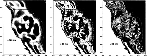
FIGURE 2.13 . Topography of the broad zone of plate boundary deformation within the western United States and adjacent portions of Canada and Mexico, at low, medium, and high horizontal resolutions (300, 80, and 20 km). The height scale ranges from 400 m (violet) to 2400 m (red). At low resolution (i.e., topography smoothed to eliminate features with horizontal length scales smaller than 300 km), only the most general topographic features of this plate boundary zone can be distinguished. At medium resolution, large features such as the Sierra Nevada begin to emerge. At high resolution, small-scale mountain blocks and valleys that are key indicators of crustal extension of the Basin and Range Province appear. The low resolution in this figure is comparable to or better than current seismic tomography images of most of the upper mantle. Obtaining seismic images at the high resolution is one of the goals of the EarthScope initiative. SOURCE: G. Humphries, University of Oregon.
|
Box 2.2. EarthScope Initiative EarthScope is an NSF initiative to build a network of multipurpose instruments and observatories that will significantly expand capabilities to observe the structure and active tectonics of the North American continent. The initiative will deploy four new observational facilities:
|
DEEP INTERIOR
Heat from the deep interior powers convection in the Earth’s liquid outer core, generating a planetary magnetic field, and in its solid mantle, driving plate tectonics and shaping the Earth’s surface environment. Mantle convection is the primary generator of the Earth’s topography, and it determines the geographic distribution of continents and oceans, the chemical composition of the Earth’s surface layers, and the chemical fluxes into the oceans and atmosphere. The surface structure that results from these deep-seated processes is unlike that of any other planet in the solar system. Venus, comparable in size and structure to the Earth, is tectonically active, but shows no evidence of plate tectonics and is devoid of a planetary magnetic field. Recent space missions provide hints that Mars, which is much smaller than the Earth, has had plate tectonics and a planetary magnetic field in the distant geological past, although neither is currently observed. Why the Earth is so different from its planetary neighbors in terms of these global features remains the subject of considerable mystery and controversy.
Major Areas of Investigation
Mantle Convection and Geochemical Reservoirs
The flow pattern of the mantle determines the thermal history of the Earth’s interior and the geological evolution of the continental and ocean floor crust. There has been no definitive means of imaging this flow pattern, however. Geophysical observations, particularly seismic tomography, provide snapshots of mantle structure, while geochemical measurements, particularly isotopic and trace element analyses, offer constraints on the past evolution of the interior; these can be related to the pattern of flow, past and present, but only indirectly. Numerical simulation of three-dimensional convection, which can now reach the parameter ranges relevant to the mantle, is proving to be an effective tool for integrating these different types of data into self-consistent models of the convection system. Laboratory studies conducted at mantle conditions provide essential constraints on the computational models and their interpretation.
Recent developments in geophysical and geochemical methods yield enormous improvements in the resolution of mantle features. In particular, seismic images now reveal that the flow driving plate tectonics, as manifested in descending lithospheric slabs, extends to the deepest regions of the mantle, at least in some areas. At the same time, geochemical data supporting the existence of two or more distinct, relatively unmixed zones of the mantle
has become compelling, heightening a controversy that dates back half a century. The sharpened resolution of geophysical and geochemical observations, in combination with high-level computational simulations of the complex time-dependent flow of the mantle, is leading to new insights about the existence and long-term (billion-year) survival of distinct geological regions within the deep interior.
The Core-Mantle Boundary (CMB)
The contrasts in physical properties at the boundary between the rocky mantle and the liquid metal of the outer core are extraordinary: the mass density jumps by an amount greater than at the free surface, and the viscosity drops by more than 20 orders of magnitude—from that of “solid” rock to a value not much greater than that of water. The heat flowing across the CMB comes from energy sources within the core large enough to power a geodynamo that produces the Earth’s magnetic field.
A great deal has been learned about this boundary in the last decade. Evidence of patches with highly anomalous seismic velocities (“ultralow velocity zones”) and strong anisotropy (direction-dependent wave speeds), as well as indications of unexpected electrical conductivity that may influence the wobble of the Earth’s rotation, are but a few of the unexpected results of recent studies. In combination with geophysical observations, laboratory investigations suggest that this is a region of intense chemical reactions, perhaps because the nature of chemical bonding is radically different at deep-Earth conditions than at the surface (e.g., oxygen, the primary constituent of rock, is a metal at the million-atmosphere pressures of the deep mantle).
The Core Dynamo and Magnetic Field
The core dynamo generates the geomagnetic field through complex electromagnetic and hydrodynamic interactions among convective motions within the rotating, highly conductive liquid outer core. Although “toy models”— simple dynamos amenable to standard theoretical analysis—have shed light on the fundamental physics of magnetic field generation, realistic simulations of the core dynamo require intense numerical calculations, and the first such numerical models were developed only about five years ago. With continuing advances in computational capabilities, these system-level models offer new possibilities for explaining observations of the geomagnetic field and core properties.
An abundance of data recently available from direct observations, satellites, and permanent observatories now reveals that the behavior of the
geomagnetic field on very short time scales—from a year to a few decades— lies at the heart of understanding some of the most important processes governing its origin and temporal evolution. This is surprising, because prior work had suggested that the field evolves only on much longer periods (104 years), far beyond the time scale of direct monitoring. Three examples are torsional oscillations in the core, the angular momentum budget of the core, and magnetic “jerks”—changes in accelerations of the field observed on the Earth’s surface.
Although the desire to understand the dynamo at a fundamental level continues to motivate studies of the geomagnetic field, there is a growing recognition that changes in the Earth’s main field have important implications for a wide range of practical issues, including biological evolution, the production of carbon isotopes in the upper atmosphere by cosmic rays (essential for carbon dating), and the exchange of angular momentum between components of the Earth system. Rotation of the planet provides a dynamic link between the climate system at the surface (atmosphere and oceans) and the fluid-solid core at the center.
Inner Core
The dense, crystalline inner core, which is about two-thirds the size of the Moon, is known to play a major role in the core dynamo process. In particular, the presence of the inner core decreases the rate of change of the magnetic field and prevents the field from constantly reversing (switching north and south poles). Some numerical simulations of the core dynamo and some observations suggest that it may rotate at a rate faster than the rest of the planet. If so, observations of this “superrotation” could possibly allow monitoring of the dynamic “climate” of the overlying fluid core. The origin, growth, and subsequent evolution of the inner core remain shrouded in mystery. However, the strong heterogeneity and anisotropy in seismic wave velocities discovered in the past few years suggest that it is a technically active region with a rich geological history.
Disciplinary Advances
The quality and quantity of data addressing deep-Earth structure and dynamics are increasing at an extraordinary rate in several disciplines: seismology, geomagnetic studies, geochemistry, and high-pressure studies of Earth materials. As with most disciplines, important discoveries about the Earth have invariably followed the development of new instruments, deployment of new networks or application of new theoretical methods.
Seismology
The academic community undertook an ambitious program to modernize the collection of seismological data by establishing the Incorporated Research Institutions for Seismology (IRIS), initiated under NSF support in 1984. The growth in the Global Seismic Network has been phenomenal and has prompted other countries to participate in this expansion. The enlarging archive of seismographic recordings has helped to clarify the structure of the Earth’s interior, substantially increasing, for example, the resolution of tomographic imaging ( Figure 2.14 ). These images provide a snapshot view of the internal dynamics that control the geological evolution of the planet.
The USArray component of the EarthScope initiative ( Box 2.2 , Figure 2.15 ) will greatly enhance the ability to investigate Earth’s interior at many scales: (1) the mantle structure beneath North America will be resolved to horizontal scales of 50-200 km down to a depth of at least 1000 km; (2) the topography and transition widths of major seismic discontinuities in the upper mantle will be resolved to tens of kilometers; and (3) the CMB structure beneath portions of the Pacific, the Caribbean, and near the Aleutians will be mapped with similar resolution. USArray will also provide the high-quality, high-density data sets needed for the joint interpretation of compressional and shear velocities.
Observatory-type studies on a planetary scale offer a number of important scientific opportunities. Large gaps exist in the global network of seismic stations that cannot be filled with island stations, particularly in the eastern Pacific and Southern Oceans. Improved spatial sampling provided by long-term, broadband seismic stations at approximately 20 ocean sites would provide much improved tomographic imaging of the structure of the lower mantle (especially in the Southern Hemisphere), the CMB, and subducting slabs and rising plumes of mantle circulation. Seafloor observatories will also provide close-in data for studies of oceanic earthquakes, which differ in substantial and poorly understood ways from continental earthquakes. A new program sponsored by the Ocean Sciences Division of NSF (Dynamics of Earth and Ocean Systems) advocates such an undertaking.
Increased computational speeds, coupled with high-speed networks and languages capable of managing parallel computations, allow calculations to be made at higher resolution and with fewer compromises than ever before. These information technologies will play a central role in the processing of very large seismic data sets and the numerical simulations of seismic wave-fields in heterogeneous, anisotropic media needed for data interpretation. These efforts could be facilitated through a better coupling between EAR and NSF information technology programs.
FIGURE 2.14 Seismic tomographic image of the shear velocity of the Earth’s mantle (G. Masters, G. Laske, H. Bolton, and A. Dziewonski, The relative behavior of shear velocity, bulk sound speed, and compressional velocity in the mantle: Implications for chemical and thermal structure, in S. Karato, et al., eds., Earth’s Deep Interior: Mineral Physics and Tomography from the Atomic to the Global Scale, Geophysical Monograph 117, American Geophysical Union, Washington, D.C., p. 63-87, 2000). Shown are perturbations with respect to the spherical average, where blue and red mark isovelocity surfaces for +0.6 and - 1.0%. Top: The map view of the shallow structure reveals seismically fast areas beneath continents and the old Pacific Ocean, whereas slow areas are found along midocean ridges. Bottom: View of the whole mantle from south to north (Africa to the left). Large-scale, low-velocity regions (sometimes described as megaplumes) are surrounded by fast, relatively narrow, slablike regions that extend across the whole mantle. The “ring” of fast velocities around the mid-Pacific low-velocity anomaly at the bottom of the mantle is thought to be the “graveyard of subducting slabs.” SOURCE: Reprinted with permission from P. Tackley, Mantle convection and plate tectonics: Toward an integrated physical and chemical theory, Science, v. 288, p. 2002-2007, 2000. Copyright 2000 American Association for the Advancement of Science.
Geomagnetic Studies
High-performance computing has allowed the first realistic simulations of the convective dynamo that creates the geomagnetic field. These numerical simulations have been used to explore the possible consequences of changing thermal boundary conditions at the core-mantle boundary and have made intriguing predictions about the possible connections between the geodynamo and mantle dynamics. Analyses of the historical magnetic field show long-standing features that persist for at least hundreds of years, and comparison with the time-averaged field over 5 million years reveals intriguing similarities ( Figure 2.16 ). The newest generation of paleomagnetic instrumentation provides measurements of an unprecedented quality. Coupled with careful field work, these new instruments permit reliable estimates of field paleointensity. Short-term variations in both direction and intensity not only furnish a means for making high-resolution stratigraphic correlations, but also place important constraints on the processes that generate the geomagnetic field. In particular, the new data can be used to develop a more detailed understanding of magnetic field reversals, and the time-averaged field can be used to understand long-term deviations from an axial dipole. Finally, extending the geographical coverage of high-resolution paleomagnetic records obtained from sediments and igneous rocks is critical for testing predictions made by core dynamo models. Drilling into high-sedimentation-rate, anoxic basins provides the best data for attaining these goals, although paleomagnetic studies of continental rocks will also yield valuable measurements.
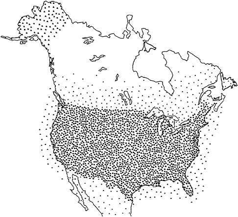
FIGURE 2.15 USArray coverage of North America including the continental margins of the United States and potential cooperating stations in Canada and Mexico. SOURCE: P. Shearer, University of California, San Diego, http://mahi.ucsd.edu/shearer/USARRAY/usarray4.html .
The current understanding of geomagnetism owes much to the geomagnetic observatories that have been maintained (in varying numbers) over the past century. Data from these observatories have been used to explore a wide range of physical phenomena, from the flow in the Earth’s liquid core, to the electrical conductivity of the solid mantle, to resonant hydromagnetic oscillations in the plasma environment of the ionosphere. From these studies much has been learned, not only about the geomagnetic field per se, but also about
the physical state and dynamics of the solid Earth and the near-Earth space environment. Advances in theory and computational capability, together with modern satellite data, provide exciting new possibilities for extending the knowledge (and use) of geomagnetism on a number of fronts. However, achieving this promise will require a global array of geomagnetic observatories, both on the land surface and on the seafloor, in conjunction with ongoing satellite measurements. The need for better distribution of geomagnetic observatories with modern digital equipment is a well-known problem. 11
Geochemistry Studies
Isotope and trace element geochemistry of mantle-derived rocks, including ultramafic xenoliths and lavas erupted at midocean ridges and ocean islands, documents the chemical composition of the deep Earth, as well as the time-integrated effects of four and a half billion years of planetary differentiation. The geochemistry of such samples provides unique insights to the formation of the Earth from the solar nebula, the processes and time scales of crust and atmosphere formation, the style of mantle convection and the origin of hotspots, and the fate of slabs subducted back into the mantle. New geochemical techniques have frequently arisen from the need to analyze mantle samples for previously inaccessible elements or with enhanced precision, speed, and spatial resolution. The results of these advances have shed new light on the deep interior, and the coming decade will continue this evolution. The new generation of thermal ionization mass spectrometers, offering enhanced precision and sensitivity for radiogenic isotope analyses, has been complemented with inductively coupled plasma mass spectrometry (ICPMS), which permits routine analyses of nearly every element in the periodic table on very small samples. In the past few years, results from the first multiple-collector ICPMS instruments have also begun to appear; this new technique permits rapid isotopic analyses with minimal chemical purification as well as analyses of elements not appropriate for thermal ionization. Advances have also occurred in the ability to map small-scale (tens of microns down to submicron) chemical and isotopic variability in crystals using both laser ablation ICPMS and secondary ion mass spectrometry. Of particular interest is the ability to analyze melt inclusions, which richly document previously unknown small-scale variability in the chemical and isotopic composition of the mantle.
FIGURE 2.16 (A) Results of numerical simulations of the geomagnetic field of Glatzmaier and Roberts. Blue lines indicate flux into the core, and orange is outward-directed flux. External to the core, the field is approximately that of a dipole. Numerical simulations make predictions about field behavior (average intensity, secular variation, behavior during reversals) for different assumed boundary conditions. SOURCE: G.A. Glatzmaier and P. Roberts, A three-dimensional self-consistent computer simulation of a geomagnetic field reversal, Nature, v. 377, p. 203-209, 1995, Reprinted by permission from Nature. Copyright 1995 Macmillan Magazines Ltd. (B) Field model UFM1 of Bloxham and Jackson. Averages of geomagnetic field observations over the last 300 years are plotted as radial flux on the core mantle boundary. Color conventions are as in (A). Although the field is dominantly dipolar, there are significant departures (flux patches with the wrong color) from a dipole model that persist for hundreds of years. SOURCE: J. Bloxham and A. Jackson, Time-dependent mapping of the magnetic field at the core-mantle boundary, Journal of Geophysical Research B, v. 97, p. 19, 537-19,563, 1992. Copyright 1992 American Geophysical Union. (C) Averages of paleomagnetic data spanning the last 5 million years. There is loss of resolution relative to the geomagnetic field average shown in (B) due to the difficulty in getting global coverage with high-quality data. SOURCE: Reprinted by permission from C.L. Johnson and C. Constable, The time-averaged geomagnetic field; Global and regional biases for 0-5 Ma, Geophysical Journal International, v. 131, p. 643-666, 1997. Copyright 1997 Geophysical Journal International.
High-Pressure Studies of Earth Materials
With the advent of dedicated synchrotron beamlines and other modern technologies, it has become possible to document the properties of Earth materials in situ, at the high pressures and temperatures of the planet’s deep interior. Measuring the elastic properties that determine seismic wave velocities; the density, thermal conductivity, and rheological properties that control geodynamic motions; and the partitioning of minor and trace elements that produce the geochemical signatures observed in rock samples is now possible at deep-Earth conditions. First-principles quantum and statistical mechanical calculations are also offering significant theoretical insights into the chemical and physical properties of materials throughout the mantle and core. Thus, the seismic anisotropy of the inner core, the possible chemical and physical interactions at the core-mantle boundary, the distribution of radioactive heat-producing elements, and the initiation of melting (or crystallization) throughout the Earth are all subject to quantitative study over the coming decade. The abundance and distribution of water and other “volatile” molecules within the planet, as well as their cycling between the surface and interior over geological history, can be evaluated for the first time. These are specific examples of the broader question now being addressed through high-pressure studies; What is the current state of the Earth’s interior, and what are the processes by which it evolved to this state?
THE PLANETS
The Earth is only one member of a rapidly growing family of known planets, both within and beyond the solar system. The extraordinary pace of planetary exploration, driven by large national and foreign investments in spacecraft and telescopes, is expected to continue for at least the next decade. Current or planned space missions will provide unprecedented detail and coverage of the geology, topography, structure, and composition of many solar system bodies; in several cases this coverage will rival or exceed equivalent terrestrial data. Similarly, it is anticipated that by 2010 the first samples collected from Mars, a comet, an asteroid, and the Sun (via solar wind particles) will be returned to Earth for direct investigation of their composition and structure. Telescopic observations of primitive objects in the solar system (i.e., Kuiper belt objects, located beyond the orbit of Neptune) and of the planets orbiting distant stars promise to provide unique data regarding the origin and evolution of our solar system.
Investigations of the solid Earth have usually been undertaken through studies of the Earth itself. However, the study of extraterrestrial materials has provided some of our most important insights regarding the Earth. For example, the age of the Earth, 4.56 billion years, was derived not from dated Earth material but by the study of meteorites (and subsequently confirmed by dating lunar samples). The baseline for discussions of the bulk composition of the Earth is likewise based on a meteorite (chondrite) reference. The richness of materials and information on extraterrestrial bodies ensuing from the next decade of exploration will provide important new opportunities for basic research into the origin, evolution, and structure of planets, including Earth. Effective use of these new data will require both a broad-based effort to promote interaction between the Earth science and planetary science communities, and a substantial enhancement of analytical capabilities.
Promise of Planetary Exploration
Robotic exploration of the solar system is increasing rapidly. The scientific opportunities provided by these missions are detailed in a number of National Research Council reports. 12 , 13 Here, the committee focuses on near-
term missions of interest to the solid-Earth sciences. Within the decade, current or planned NASA or international missions will provide the following:
-
Surface topography, gravity, and magnetic field data of unprecedented resolution for the terrestrial planets and for some satellites: For example, the Messenger Orbiter will define Mercury’s gravity field and Cassini flybys will refine the gravitational parameters of some Saturnian satellites. High-resolution geophysical observations, such as those collected by the Mars Global Surveyor (MGS) mission, are critical for identifying and understanding the geologic processes that shape solid planets. While much is known regarding these processes on Earth, existing data leave little doubt that conditions on other planets and satellites can yield fundamentally different results ( Figure 2.17 ).
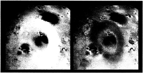
FIGURE 2.17 Active volcanism on Jupiter’s moon Io from the Galileo spacecraft. The true-color image on the left shows the ~1300-km-diameter red ring of sulfur surrounding the volcano Pele. The false-color infrared composite on the right reveals the glow of hot (up to 1027°C) magma in the volcano’s central crater. SOURCE: NASA Jet Propulsion Laboratory.
-
In situ chemical and mineralogical analyses of the surfaces of Mars, satellites, asteroids, comets, and the solar wind (complemented by samples returned from these same sources): These data will open an exciting new
-
research frontier documenting and understanding chemical processes that produced the solar system and that modify both the surfaces and the interiors of solar-system bodies. Such work was largely impossible from the earlier generation of orbiting spacecraft. The results will be important in a wide array of Earth and planetary science disciplines. Some key research areas benefiting from these observations include the composition and early evolution of the solar system, the climatic history of Mars, and the possible existence of life beyond the Earth.
In addition, data collected from ongoing missions (e.g., the surprising diversity of Jovian satellite magnetic fields detected by the Galileo mission) will be analyzed over the next several years. A lengthy period of analysis of satellite data, combined with other geophysical observations, is important for understanding the chemical and physical structure and dynamics of planets.
Science Opportunities
Continuing exploration of the solar system, particularly Mars, will provide both new opportunities and challenges for the Earth science and planetary science communities in the coming decade ( Box 2.3 ). On the one hand, new high-resolution observations of key physical, geological, chemical, and mineralogical characteristics will permit insights to the processes occurring on and in other solar system bodies. As the quantity and quality of observations approach those for the Earth, the knowledge-base within the Earth science community will become increasingly important for interpretation and comparison. On the other hand, these observations will also contribute to an improvement in our understanding of Earth and the solar system as a whole:
-
Geological and geophysical processes occurring on other planets are responses to the same basic forces as on Earth, but applied in different ways to materials with different properties and subject to different boundary conditions. As such, these systems will provide new environments for investigating basic planetary phenomena.
-
Unlike the Earth, which is continually resurfaced and eroded, many bodies preserve a physical and chemical record from the earliest days of the solar system. Thus, they provide data regarding planetary evolution that no longer exists on Earth. For many fundamental processes that occur early in a planet’s history (e.g., formation of the first crust), the Earth’s record is extremely difficult to decipher.
-
Distinctive chemical and isotopic composition is a first-order property of the solar system, and the new data likely to be obtained over the next
-
decade are critical for furthering understanding of the processes of mixing, accretion, and differentiation of planets and meteorite parent bodies.
-
Processing local resources to obtain various materials will be crucial to the establishment of self-sufficient planetary bases. 14 The study of soil formation and past aqueous weathering on planetary surfaces will be a prerequisite for developing extraterrestrial “soils” for growing plants. The factors that influence the activity, ecology, and population dynamics of microbes in soils are important for nutrient cycling, biodegradation, and regenerative life support on a planetary base.
|
Box 2.3. Recent Studies of Mars NASA has identified exploration of Mars as a top research priority, and early results of this focused effort are now being obtained. These results illustrate some of the basic research opportunities and challenges posed by intensive solar system exploration: 1 , 2
|
|
Analytical Challenges
In situ planetary studies will offer great benefits for Earth and planetary scientists, 15 but sample return offers the most promise for research funded by EAR. Samples brought back from various solar system bodies will share a common trait—the amount of material will be extremely small, ranging from perhaps a kilogram of Martian soil and rock to submilligram quantities of comet dust. In comparison, hundreds of kilograms of lunar materials were returned during the Apollo program. The small sample sizes, coupled with the
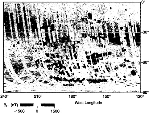
FIGURE 2.18 Clues to the ancient magnetic field of Mars from the Mars Global Surveyor spacecraft. This image documents the strength and variability of magnetization recorded by Martian crustal rocks. The pattern indicates the existence of an Earth-like planetary dynamo operating in the Martian core, but only very early in the history of the planet. The alternating polarity pattern records fundamental, yet previously unknown aspects of the formation of the early Martian crust, possibly by a process similar to seafloor spreading on Earth. SOURCE: Reprinted with permission from J.E.P. Connerney, M.H. Acuna, P.J. Wasilewski, N.F. Ness, H. Reme, C. Mazelle, D. Vignes, R.P. Lin, D.L. Mitchell, and P.A. Cloutier, Magnetic lineations in the ancient crust of Mars, Science, v. 284, p. 794-798, 1999. Copyright 1999 American Association for the Advancement of Science.
need to investigate the samples for a tremendous diversity of purposes, place a new and extremely strict requirement for high-efficiency analyses. In addition, many types of analyses will require extremely high spatial resolution. For a
number of critical measurements, present techniques and instruments are simply not adequate.
An important challenge will be to construct appropriate instrumentation for these analyses. The necessary instrumentation is diverse, and includes advanced ion microprobes, mass spectrometers, and electron microscopes, as well as accelerator- and synchrotron-based analytical probes. This challenge, if met, is an important opportunity for the Earth science community. As evidenced by the blossoming of isotope geochemistry following the instrumentation campaign associated with the Apollo program, the creation of new techniques and capabilities can invigorate an entire field for many years.


